 Post:
Post: Further fun with Flickr
I mentioned previously that Flickr has implemented a geotagging system to allow users to mark where their photos were taken, in addition to when (Exif data) and of whom or what (tags). I mentioned that this seemed to be a fantastically cool feature.
I have now used it, and can confirm that it is a fantastically cool feature. The only thing that lets it down is the Yahoo! Maps system. This point has been laboured to death on blogs and in comments everywhere, so I won’t spend too long on it, but the paucity of Yahoo!’s road mapping data in the UK and Europe defies belief, especially when compared side-by-side with Google Maps’ offering. This introduces something of a trial-and-error aspect to geotagging photos taken over here in Britain: a postcode or city name search will get you to a screen containing the area you’re looking for, but quite where on that screen you took your photo is something you either have to take a guess at or fathom out from the satellite photo; all of this makes the geotagging process much more complicated and frustrating than it needs to be, especially in those areas where even the satellite photo quality is poor (most of Oxford constitutes a notable example).
So that’s the problem: what’s the solution? One option is to badger the Yahoo! people to get their road maps updated, but they know about the problem already and are working on it (as the Flickr team have stated on their blog), so further badgering isn’t likely to help anyone. Another option would be to develop some kind of mashup, application or GreaseMonkey script to allow people to geotag their photos through Google Maps instead, bypassing Yahoo! Maps entirely: I don’t doubt that someone with more time and more experience than myself is already working on this. My current solution is a little more labour-intensive but allows for rather more precision than the hunt-and-hope approach affords.
For this, I use:
- One copy of Google Earth
- One web browser pointed at a converter between the degrees-minutes-seconds system and the fractional degrees system used by Flickr’s geotagging: I’ve used the converter on the FCC’s site, but there may be better ones out. Or use a calculator.
- One web browser pointed at Flickr’s geotagging interface.
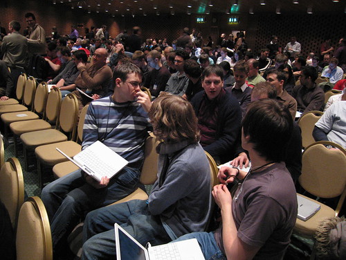
By way of an example, I am going to use a photo I took at the Carson Summit in London back in February:
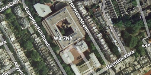
A little bit of research reminds me that the summit took place in the Kensington Conference and Events Centre, the postcode for which is W8 7NX. Look that up in Google Earth:
Now I have a location for the photo, but I need to get its co-ordinates from Google Earth somehow. Right-clicking (or Ctrl-clicking on the Mac) and selecting the “Get Info” option brings up a panel supplying latitude and longitude.
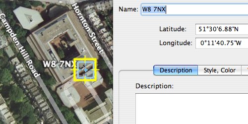
Now I have precise co-ordinates for the building in which I took the photo: so far, so good. However, to get them into Flickr, they need to be converted to a number of degrees only rather than a combination of degrees, minutes and seconds. One trip to a converter site later…
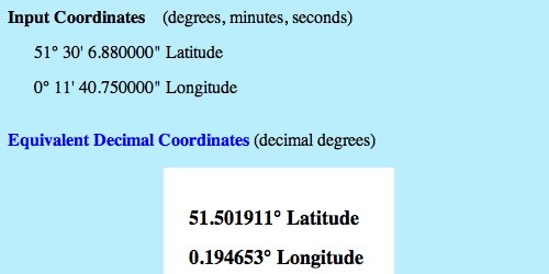
…and I have co-ordinates in a format Flickr will accept. One slight gotcha with this method is that the converter I’ve chosen will not deal with negative numbers (South for latitude, West for longitude), so I need to remember to put that back in later: in this case, the longitude is to the West of the zero meridian. It’s a small detail but an easy one to forget, and I have accidentally dumped more than one person in the North Sea by forgetting it.
In Flickr’s geotagging interface, double-clicking a photo within the reel at the bottom of the window will open up a dialog box with a number of tabs at the top: one of these is “Location”, and it contains fields to enter latitude and longitude manually (again, note the negative longitude).
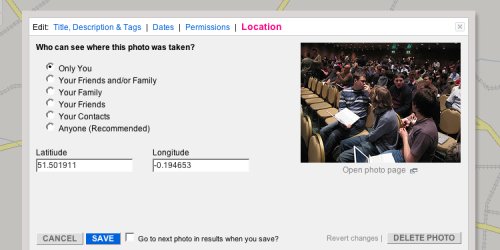
Set up some permissions if necessary, save the changes, and have a check on the map to make sure that it’s correct.
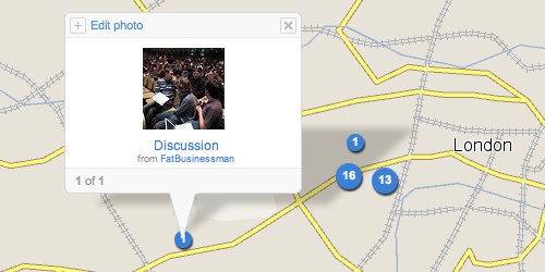
Voilà! One accurately geotagged photo!
For single photos, this is pretty labour-intensive (although after the first few times I find I can get into a pattern and get up to a fairly respectable speed): for multiple photos, of course, it only needs to be done once, and subsequent photos may be dragged onto the initial marker in no time whatsoever. Is this a quick and efficient solution? Most assuredly not. Is this a good solution? Probably not even that. But it’s a good enough solution until Yahoo! Maps becomes usable for anyone not from the States.
If you prefer Google Maps instead of Yahoo Maps for mapping your photos and you care about accuracy, our project, Panoramio, may be interesting for you. Btw, you can later watch the photos in Google Earth KML feed,
Eduardo
Yes indeed, another potential solution is “look elsewhere for online photo management”. The only problem with that solution, of course, is that it involves abandoning Flickr completely and losing all the lovely network effects. Network effects on Flickr are very strong.
Have you tried the bookmarklet from Summato (http://labs.sumaato.net/scripts/). This allows you to geotag images using Googlemaps directly from Flickr. Once done you can then get Flickr to reimport all your geotagged images to thie new format – this option is in the accounts settings.
I found a mashup of Google Maps which works out the Lat and Long values in decimal – takes a couple of steps out of your method.
http://www.satsig.net/maps/lat-long-finder.htm
Having just spent a little time geotagging this evening, I must admit I love using Google Earth to find the locations: Speed and responsiveness for the win.
To take many steps out of your process though, I did discover this. Open Google Earth’s preferences, you’ll see an option group called ‘Show Lat/Long’ in which you can select ‘Degrees’, rather than the default ‘Degrees, Minutes, Seconds’. Now all lat/long measurements are displayed in Flickr compatible format, and is displayed right where you cursor stops. So find your spot, pause the cursor and note the Lat/Long at the bottom of the map, Tab over to Flickr and enter the details. If you can do it all with keyboard shortcuts, you can even keep Google Earth’s status bar visible while you’re in Flickr and just copy direct
In fact, after you ⌘⇥, the values in the Google Earth status bar remain static when you move the mouse.